Ground Control


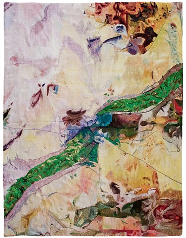


Ground Control is a series of wool tapestries that depict satellite images of the US/Mexico border at current and historical places of conflict. The series is informed by the unique socio-political climate of the border and the imaging technologies used to uphold it. The electromagnetic images used in this project are collected by US government satellites used for “remote sensing” of the earth’s surface. Unlike photography that attempts to mimic the function of the eye, remote sensing collects data and constructs images through a process antimemetic to human experience. Without data visualization (the process used to assign a data set with a visual representation), remote sensing exists as an intangible and invisible abstraction, a radical extension of the Cartesian worldview.
The tapestries in Ground Control are woven in Guadalajara by the tapestry workshop, Taller Mexicano de Gobelinos, in exchange for the amount of money it costs a family of four to be smuggled across the US/Mexico border at the time of production. This atelier was selected both for their location in Mexico as well as for the expertise of the weavers in Gobelin tapestry, a craft that was developed in the 1500s for the French monarchy to copy paintings and which can only be produced by hand. The labor that is required to produce hand-woven tapestries made them exclusive during the Renaissance and nearly extinct after the invention of the first mechanized looms, which ushered in the industrial revolution and were some of the first inventions to implement digital punch cards. Ground Control exists at this intersection of digital surveillance technologies and the history of global capitalism, as well as the way in which our desire for images and the desire for mastery by way of image-making has functioned both to facilitate and to propel the colonial project.
By translating remote-sensed images (remote both to human experience and physical location) from a digital screen-based medium into handmade wool tapestries and then exhibiting them on the ground as rugs, Ground Control reconnects the abstracted image of the earth with the earth itself, and with an embodied presence that engages with the viewer in tactile, visual, and performative ways. The remediation from immaterial, virtually-generated satellite image to tactile hand-woven wool critically reimagines the machine vision representation of the US/Mexico border by historicizing the reproducible digital image into a unique object reminiscent of high modernist paintings. Ground Control embodies the contradiction that the source images hide, that these seductive abstractions illuminate and facilitate acts of violence, uphold the assertion of boundaries between cultural and political institutions of power, and reinforce the panopticism of the Enlightenment worldview.